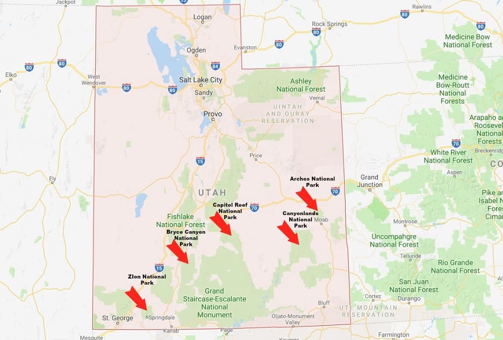
The Mighty 5 Utah National Parks are a wonder to behold. Altogether there are 5 National Parks in Utah – second only to California and Alaska which have 8 each. However, when comparing the size of Utah to these other 2 states it is an impressive statistic.
In fact, when adding together the Utah National Parks and Monuments, and other federally owned land located in the state, over 63% of the land in Utah public. When looking at a Utah National Parks map you quickly realize that the parks are also grouped into the lower half of the state so the Big 5 locations are only a few hours drive at most from each other.
For an outdoor enthusiast, a Utah road trip becomes an imperative! There are just so many places to go in Utah. According to a US News and World Report opinion poll, 3 of the top 10 National Parks are in Utah. What is even more impressive is that each of these parks is unique in its own right- so much so that it is hard to believe that they are all so close together.
Where else can you find such diverse scenery, world-class hiking, ample space for camping, and just general awesomeness all easily accessible in a week’s vacation? Yes it IS possible to do a Utah National Parks loop in only a week.
Utah National Parks Map
Of course, while that CAN be done, we do NOT recommend it. National Parks are there to be enjoyed and explored and visitors should go to take their time and absorb the awesomeness. The Roving Foleys do not do Utah in a week. We stay… we hang around… we explore.
We spent 3 months in the Mighty 5 Utah National Parks this year and it was everything we had hoped for and more. We tried out boondocking for the first time on our Utah trip, and we could not have asked for a better introduction. For anyone getting out on the road, a Utah trip is an imperative!
In fact some of the best places to camp in Utah can be found not in campgrounds, but on Federal lands just outside of the Parks. There is ample space for boondockers near all of the parks and most of it offers tremendous views, a quick entrance to the parks, and most of all…it’s FREE!
Here are The Mighty 5 Utah National Parks
(In order of annual traffic)
We have not only tried to give you first-hand information about the parks, but also a bit about the local areas, towns, things to do, etc.
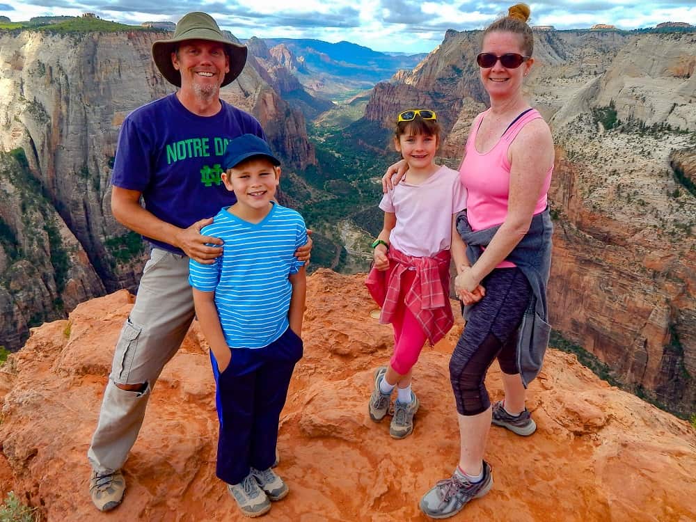
The Mighty 5 Utah National Parks: Zion
Our road trip through Utah starts at Zion. Zion National Park is the busiest of the Mighty 5 Utah National Parks and the third busiest in the United States, drawing nearly 5 million visitors each Year. That number grows annually. In fact, Zion jumped from 5th place in 2016 due to record numbers of visitors discovering the majestic views and hiking that is unmatched anywhere on the planet. Of course, that means one thing- crowds! Visiting Zion can be quite an ordeal depending on when you choose to see it.
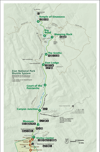
The main entrance to the park is at the south end of the canyon and travels north up the ever-narrowing corridor along the north fork of the Virgin River. There is an intersection at Canyon Junction which is where the East entrance comes in along the winding Zion-Mt Carmel Highway. This is also the farthest into the park you can drive your personal vehicle unless you are staying at the lodge.
The increase in visitors has caused the park to limit auto travel and utilize a shuttle system. People are strongly encouraged to park at the Visitors Center and take the shuttles from there.
The park is also home to the Zion Human History museum which chronicles the history of the Indian people as well as the Zion Valley and its growth over time. The museum has some very interesting exhibits and a nice outdoor area where they hold Ranger talks.
The views as you drive up the road into the canyon are breathtaking. Mammoth granite and limestone walls tower above you. As you stop at each of the shuttle points, you are treated to spectacular scenery. Our personal favorite stop was at Big Bend, where you can look up to see hikers along the knife-edged Angels Landing Trail. They are like ants moving along the precipice and even from the ground it makes your heart skip a beat.
The road continues to wind along out to the Temple Of Sinawava which is the stopping point of the road. From there you can continue on foot along the Riverside Trail and into the Narrows. The Narrows is arguably the most well known and visited place in the park.
At this point, the canyon has narrowed to the point where the 1000 ft tall walls are only separated by the river. The river can be hiked for miles into the ever-tightening and twisting passageway until it resembles a slot canyon.
For all of the shuttle stops, and trails, download an official Zion National Park Map.
Zion National Park Map:
Zion National Park: Sites/Hikes
Zion National Park has some absolutely other-worldly hiking. There is something for every hiker from the casual paved Pa’rus and Riverside Trails to the heart-stopping Angels Landing. Angels Landing and The Narrows are by far the most hiked trails and hiking them in season can be a bit like waiting to ride a roller coaster at Disney…during Spring Break.
This park has a ton more to offer so pick a trail that works for you- then go EARLY! Lines for the buses can get extremely long during the summer and the heat is… freekin’ hot! Our favorite hike was the Observation Point Trail. This hike starts at Weeping Rock and climbs. That is it… it just climbs. 4 miles of almost constant uphill, it is quite strenuous.
But when you get to the top, you are looking right down the length of the entire valley. It is breathtaking and well worth the fatigued muscles and soreness the next day. You are also looking down at the hikers on Angels Landing several hundred feet below…nah nah. We chose not to hike Angels Landing as the kids are a bit young for it but hopefully will be back for that one in a few years.
The Narrow as mentioned earlier is quite beautiful. We made the mistake of hiking that first thing on a cool morning. Once you get a few hundred yards in, there is no more land so you are hiking in frigid water that gets quite deep at times. Once it got up to the “woohoo” level (guys you know what I mean) we decided to turn back.
We would have liked to hike further in, but next time through. Other notable hikes are the Emerald pools trails which offer beautiful pools and waterfalls, Kolob Canyon which has several trails. Kolob is accessed from a different point along the West side of the park. The subway trail and Lava Point can be accessed along the Kolob Terrace Road going north out of Virgin.
Zion National Park: Surrounding Area
The area around Zion is a mixture of nice touristy towns and Federally owned land. Springdale right outside the entrance is a beautifully maintained town. It is exceptionally touristy but does have many places to stay, eat and shop. There is also a town shuttle system that links into the park shuttle system so if it is a busy day, you can park somewhere in town (for a price) and shuttle into the park.
The town of Virgin is not really a town, but a place. There is nothing there. Hurricane is a few miles down the road but does have many more of the day to day services you may be looking for as well as many more accommodations and more reasonable prices. From there you can shoot down to St George if you need Walmart, Sams Club, or some of the larger retail chains.
Zion National Park: Camping
There are a few campgrounds in the South Entrance area. There are 3 National Park Service campgrounds– none of which has full hookups. The Watchman Campground has electric hookups but the South Campground has none at all. Both parks are very reasonable in price (@$20.) Reservations are recommended WAY in advance as these campgrounds are full every day of the season.
Lava Point also has a small campground but it only has 6 sites and vehicles over 19 feet are not permitted. There are a couple of private campgrounds in the Springdale area as well but not nearly as many as you would expect given the traffic to this park. They do tend to be a bit on the expensive side.
The area around St George also has several campgrounds if you don’t mind a longer drive into the park. There are a good deal of options for free camping near Zion National Park. We boondocked just outside of Virgin and were only 10 minutes from the park. There were a lot of sites available. We found these to be some of the best places to stay near Zion.
Get more information on boondocking sites near Zion. If you are new to boondocking, see our Beginners Guide.
Zion National Park: Weather
Depending on the season, weather in Zion can be unpredictable. Summer months tend to be very hot during the day. The climate is dry. This is the busy season for tourists as well and long waits for shuttles and on popular hikes can leave you exposed to the blazing sun.
Shoulder months (April/May and September) are much better for visiting as crowds are lessened, however weather- especially in spring- can be very unpredictable and hiking in slot canyons is more dangerous due to high water levels.
Many of these types of hikes (The Narrows) may be closed due to snow melt. Check conditions carefully. Winters are relatively mild in Zion and snowfall usually melts right away at lower elevations. However the upper elevations do get a snowpack and some areas are closed to hiking and camping during the cooler months.
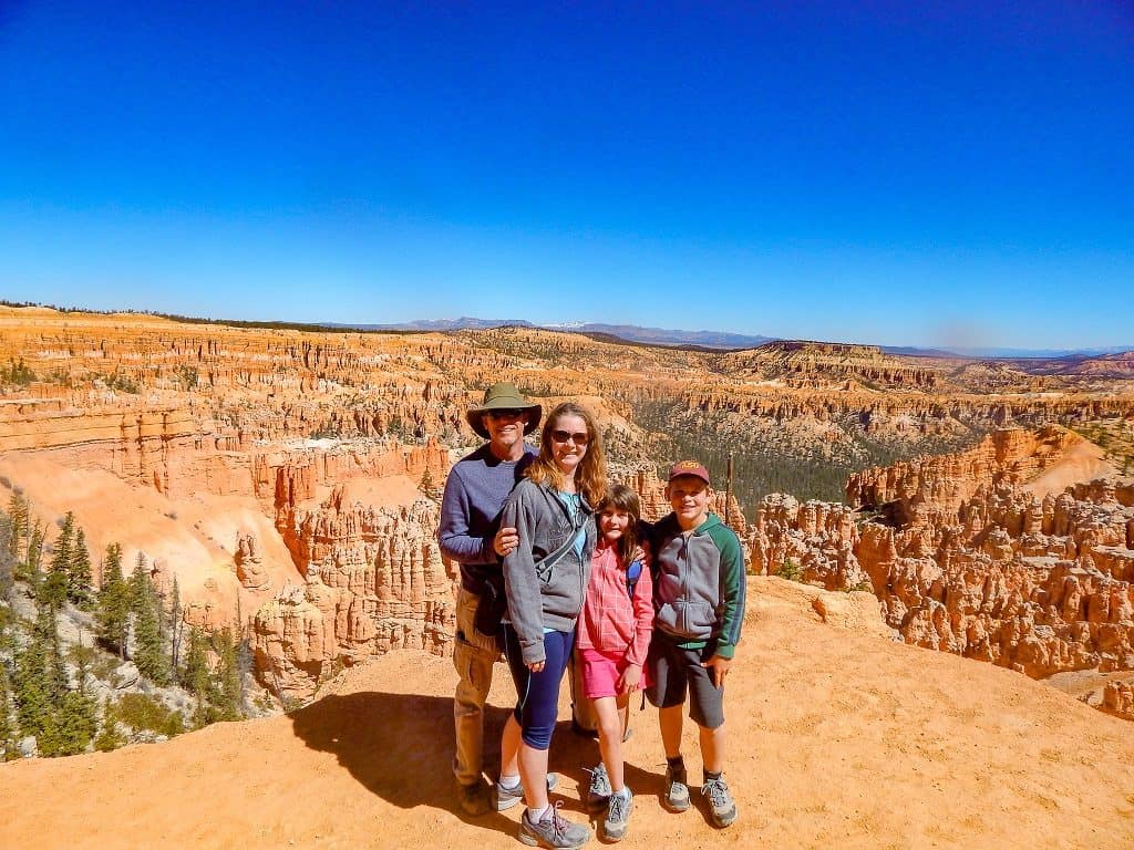
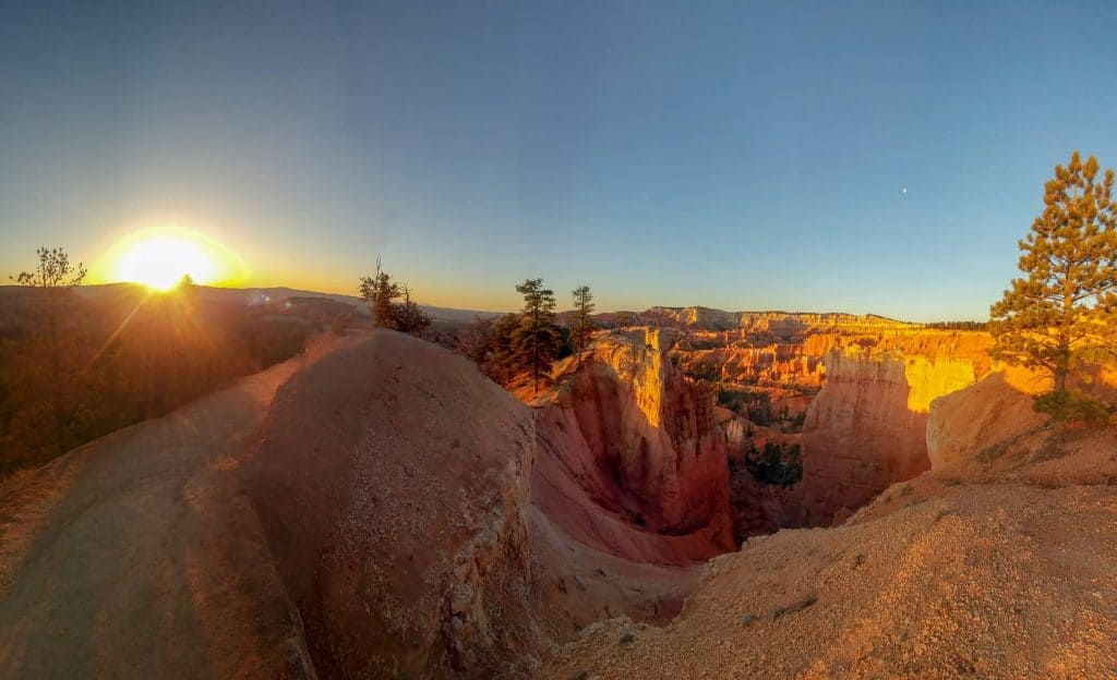
The Mighty 5 Utah National Parks: Bryce Canyon
You do those hoodoos that you do so well! Of all the great places to visit in Utah, Bryce Canyon is a favorite for the Roving Foleys. Bryce, in truth, is not actually a canyon, but a slowly receding cliff face. The forces of weathering and the unique freeze-thaw cycle, combined with the makeup of the earth in this area cause the erosion to leave behind tall multicolored pillars, called hoodoos.
The recession of the land has formed several massive amphitheaters filled with these unique structures. Between the amphitheaters are “points” which are the main viewing areas. All are accessible by car and trail and each has its own unique views.
The park sits atop the massive Grand Staircase which is a series of exposed layers of the earth, running all the way down to the Grand Canyon, some 150 miles to the south and about 6000 feet down in elevation. As the crown of the staircase, the exposed rock of Bryce Canyon is the youngest and most easily eroded.
This park is certainly other-worldly as the hoodoo can be seen to resemble people, animals etc, much like looking at clouds. Many of these spires have been named by the Indians who inhabited the place through history, or by the white men who followed.
This park is a hikers paradise with trails for every level of hiker. All of the park roads and amenities lie along the upper rim, so most trails start out by heading down into the amphitheaters and then come back up. For that reason, many of the trails have quite large vertical elements. That combined with the elevations 6000ft and up making some of the hikes challenging although they are all well-worn trails.
In the wooded areas along the main road, it is quite common to see Mule Deer and Pronghorn. The latter come into the open fields in early summer to bear their young. The views from the rim trail are spectacular, not only down into the hoodoos, but into the valleys and mesas far beyond.
Shuttle service is available at this park and recommended, although all of the main viewing points are accessible by car. During the busy times, it can be quite difficult to find a parking space, so the shuttles are a great way to see everything without the hassles of driving. The service runs right out of the park and to the main depot in the town of Bryce City, outside the entrance.
The shuttle service offers a twice-daily guided bus tour of the entire park. We HIGHLY recommend this tour if at all possible. It takes about 4 hours and is chock full of great information, history, etc. Our kids loved it and the drivers were really good with the kiddos and answered their zillions of questions.
Between Sunrise and Sunset Points is the Bryce Lodge, a nearly century-old accommodation. It was built using local materials and is known for its rustic charm, and curvy roofline as well as a good deal of the original curvy glass in the windows. There is a General Store nearby for park visitors to get trinkets and food as well as a restaurant in the lodge.
Continuing up the highway past the main visitors’ areas you can continue in the park all the way up to Rainbow Point and Yovimpa Point which is the top of the park at 9100 ft. These 2 spots are a must see, as Rainbow Point overlooks the entire park to the north, and Yovimpa Point offers views of the entire Grand Staircase all the way down to Lake Powell, and the North Rim of the Grand Canyon. There are several impressive stopping points along the road as well including great views of Thunder Mountain which was the model for Disney’s Great Thunder Mountain Railroad.
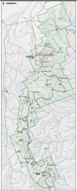
Bryce Canyon National Park Map
Bryce Canyon National Park: Sites/ Hikes
Hiking in Bryce National Park is absolutely fantastic. Just make sure you bring all the right supplies to have a great day. There are all kinds of trails. There is a paved “Shared Use” trail that runs from the shuttle station about 5 miles into the park ending at Inspiration Point. Plans are underway to extend it even farther. There are many trails that run down into the canyon and back up to the rim and even one that will take you to the town of Tropic at the base of the canyon.
If you are not able for the hike back up to the rim, using this trail to connect into the park trails and out again is a great way to see the base of the hoodoos without the heavy incline. If you prefer to view your hoodoos from above, the rim trail runs the length of the main park and is even paved in a small area between Sunrise and Sunset Points.
Our favorite trails were Fairyland and Queens Garden. The Fairyland Trail is less traveled as the trailhead is at Fairyland Point. This is the first point in the park, but the access road is outside the entrance and the shuttles do not go there. For those reasons this spot is largely passed by and therefore less crowded. Both trails drop from the rim trail down into the valley and then connect with other trails to get back up again.
Both trails also make use of the Rim Trail to complete the loop. Both of these trails offer spectacular scenery. The Queens Garden Trail even has a few “doorways” through the rock and returns to the rim by way of the Navaho Loop trail which winds up the face of the cliffs on sharp switchbacks and lands you at the top near the unbelievable Thor’s Hammer hoodoo. See our article on hiking Bryce Canyon National Park With Kids.
Bryce Canyon National Park: Surrounding Area
Bryce Canyon is somewhat remote from the standpoint of towns. The town of Bryce City is right outside the park entrance but is made up of the famous Ruby’s Inn, a few restaurants, campground, and hotels. The town has an interesting history.
Ruben Syrett, an early settler of the area, after visiting of Bryce Canyon, built a lodge near the rim to host visitors. When the park became a National Park, Syrett moved the lodge (Ruby’s Inn) down to his ranch where it still sits today. He donated land to the state for roads and as the park grew so did his business.
The town has now incorporated, but still, every business in it is owned by the Syrett descendants.
The park sits just off of Utah Scenic Byway 12 which runs all the way to Capitol Reef National Park and is considered to be one of the most scenic stretches of road in the world. Nearby on Hwy 12 is Red Canyon, another awesome example of hoodoos on a much smaller scale.
The towns of Tropic and Henrieville are also nearby as well as Cannonville which is also the entrance to Kodachrome Basin State Park. See our post: 8 Kid Friendly Activities To Do At Bryce Canyon National Park.
Bryce Canyon National Park: Camping
There are 2 campgrounds within Bryce Canyon NP. Neither has hookups but they do have a dump station. Fees are $20 -$30 per night. Outside the park, Ruby’s Inn does have a fairly large campground. Being so close to the park the rates are a bit high. There are several more campgrounds along Highway 12.
We stayed a month at the Hitch N Post in nearby Panguitch. Nice park in a nice town. About 20 minutes from Bryce. The area also offers a good deal of Federal land that can be boondocked on. Even though we did not boondock here, we did look around and there seemed to be ample opportunities in the areas along Highway 12. See our review of the Hitch N Post Campground near Bryce.
Bryce Canyon National Park: Weather
At 9000 ft elevation, the climate in Bryce Canyon is very cool. The canyon experiences an overnight freeze almost all year through. There are about 200 freeze/thaw cycles annually which is why the valley is shaped the way it is. Summer temps can be nice and warm, but the spring is unpredictable.
Snow is common in April but so are warm days, so check carefully when you plan to go. We were there the month of April this last year and had an awesome experience. We did have snow a couple of times but it was gone quickly. It was a really nice time to be there because there were no crowds.
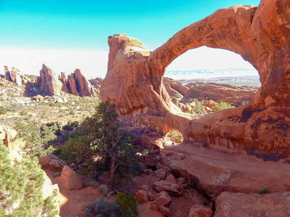
The Mighty 5 National Parks: Arches
Arches National Park is very unique. It is the largest collection of natural arches in the world. There are over 2000 arches in the park. There are also a ton of other formations like sandstone fins, and balancing pillars. The red rock formations are absolutely mind-blowing and unlike anything, you will see anywhere else. It is primarily a driving park- there is one main road that goes from the main entrance to all of the main viewing points. A couple of side roads as well lead to points of interest. On the whole there are just a TON of things to do in Arches National Park.
The drive out is about 20 miles to the end and begins with a dramatic uphill climb just past the Visitors Center. At the top, you will have stunning views of the Moab Valley and Moab fault which follows the highway below. As you travel deeper into the park, each stopping point has trails that will lead to the various arches and other formations. Some of the best hikes in Arches National Park are very near the road with short easy trails to access the arches directly, and some require some pretty strenuous hiking.
This park, while not a busy as Zion or Bryce, does get a lot of traffic. During the summer months, there is a long line at the entrance each morning at about 9 am. Since there are no shuttles here- the parking areas at each stopping point can get full. Prepare to wait and drive around for a parking spot. Then prepare to wait your turn to get that amazing photo of your family inside the arch. Crowds aside, the views are worth every minute spent getting there.
What is really nice about this park is that there is enough to see for anyone regardless of time or hiking ability. If you only have a few hours, you could simply drive the park out and back and you would get to see a lot of beautiful scenery. Stopping at a few of the easier access points you could get right up to some of the formations. Windows, Double Arch, Balanced Rock, Courthouse Towers, Delicate Arch, and The Fiery Furnace are all easily visible from the road.
Many more sites are a short walk from the parking areas. The recommendation though is to come here with some time to spend and your hiking boots. Those who endeavor to hike some of the longer trails are rewarded with even more spectacular sites.
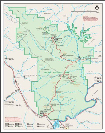
Arches National Park Map
Arches National Park: Sites/ Hikes
From the moment you enter this park, you are treated to some incredible sites. The entire park sits on a raised plateau so accessing it requires you to drive up a dramatic set of switchbacks. It is a very good road, but those who are nervous about heights, well- close your eyes!
Once on top, the drive through the park is just epic. The scenery changes to all manner of landscape and all of it is awesome! You first will come to the Park Avenue Trail. It is a short trail leading to the Courthouse Towers. We did not hike this trail as the towers are readily visible from the road.
You will then drive through the Petrified Dunes which resemble…well…petrified dunes. Then past Balanced Rock, probably the parks most famous non-arch feature. A massive boulder sits 125 feet in the air, balance on an ever eroding spire. Eventually, this structure will collapse as its sister structure “Chip Off The Old Block” did in 1975.
From here, a side road will take you out to the Windows and Double Arch. There are several great features along this road and most are easily accessible from the parking area. Farther down the main road, you pass by Panorama Point and there is another side road which takes you out to Delicate Arch. This is arguably Utah’s most famous arch as it is the one they featured on their license plates.
There is a viewing area for Delicate Arch, but the hike out to it from Wolfe Ranch is highly recommended if you are able. The hike is strenuous and involves scrambling up the slope of a massive rock ledge. The views at the top, however, are well worth the effort as you can get right under the arch for some amazing photos. Wolfe Ranch itself is worth a bit of time to explore. There is some great history as well as petroglyphs very nearby.
Moving back along the main road you will pass through the Salt Valley where you can see exposed bits of the massive salt layer on which the park sits. This salt layer and its interaction with the layers of sedimentary rock that lie over it are in great part responsible for the geography of this area including the formation of fins and arches.
The softer salt is liquefied by the pressure of the heavier overlaying rock and pushed into dames, shoving the layers of limestone upward onto their edges and producing the fins. As weathering takes its toll, many of the fins become thinner and thinner until the middle sections fall away causing the arches to be formed. Speaking of fins, just past the Salt Valley is the Fiery Furnace of the park. This hiking area requires a permit or inclusion in a ranger-guided hike. There are rows and rows of sandstone fins in this area and hiking between and around them, it is easy to become lost, thus the restrictions on open hiking.
A little farther down the road, however, is Sand Arch. Here you can take a very short hike in between the fins to find the arch hidden in the middle. This is a great place to let the kiddos run free for a while as they love to scramble over the find and there is a very beachy sand layer on the ground. Broken Arch is also nearby. Back on the road, your next stop is the end of the line. The campground is out here as well as a number of arches to hike to.
Skyline is a fairly short hike away and quite iconic. Landscape Arch, arguably the most iconic arch in the park is also only a short hike away. This massive arch is 300 feet across- the longest in the park and one of the longest in the world. It is only 11 feet thick in the center and is also famous for a large collapsed section that fell off in 1991 while a photographer ran the video. It is absolutely stunning and no trip to Arches National Park would be complete without viewing this miracle of nature.
Stopping here, as many people do, you miss the huge rewards that wait for those who continue down the Devils Garden Trail for another few miles. Several arches line the extra-adventurous path culminating at the Double O Arch and Dark Angel, a 150 ft tall black sandstone monolith.
If you are adventurous enough there are petroglyphs nearby as old as 6000 years. The trail itself is an adventure as you will find yourself scaling and walking along the knife-edged fins high above the ground. Exploring along this trail reveals some very interesting rock formations including some balancing rocks that look as if they came from the Jetsons planet. We did some really awesome hiking at Arches National Park.
Arches National Park: Surrounding Area
Arches National Park sits just a few miles outside of Moab, UT a tourist town with a very nice “towny” feel. There are ample services, restaurants, hotels etc. for the crowds that gather during the high season at the park. The Colorado River runs through the north end of town and is in fact, the southern border of the park. There are many things to do in Moab.
This town is an outdoor adventurers mecca and you can find just about any outdoor activity you can imagine offered in this town from SUP’s on the river, to 4 wheel driving in the desert, to hot air ballooning high above. The town is also the launching place for adventures into Canyonlands National Park- both the Island In The Sky and Needles Districts. The town is so popular that sometimes people call Arches- Moab National Park.
Arches National Park: Camping
There is one campground inside Arches National Park and it is all the way at the end of the park road. There are 51 sites- no hookups. The daily rate is $25 and this campground is beautiful. We did not camp there but did take the opportunity to ride through after our Devils Garden hike. It is full pretty much every day during the busy season and first come first served during the winter months. We have a 38′ fifth wheel and the thought of driving all the way through the park to get to the campground is a little terrifying. However, if you have a smaller rig, it would be an awesome place to stay for a few days.
Moab also has quite a few campgrounds. They will be a bit more expensive and also tend to fill up so reservations for any of them are recommended.
Boondocking around Arches is plentiful. There is a ton of Federal Land and sites are available almost always. We boondocked on Willow Springs Road just north of the park. There were bunches of sites and plenty of people coming and going. Very pretty area and we were lucky enough to meet some other full-time families camping there also.
Arches National Park: Weather
Arches National Park sits on part of the Colorado Plateau which makes it a “high desert” region. Weather can be very unpredictable during certain times of the year, especially in the late summer when monsoon rains can cause flash floods. The summer months tend to be very hot- many times temps go above 100 degrees. The best visiting times weather-wise are March/April and September/ October. OF course, the crowds understand this as well and these months are the busiest in the park as well.
We stayed in May this year and it was super busy with long lines to get into the park even by 9 am. December thru February tend to be cold- not much snow, but very cold overnights
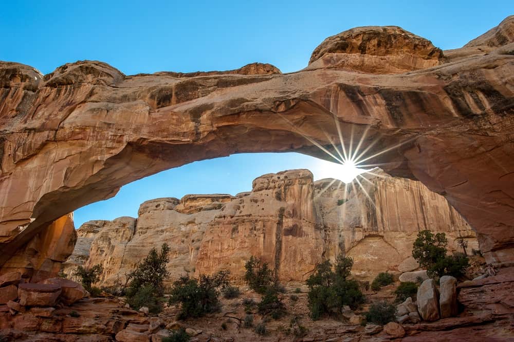
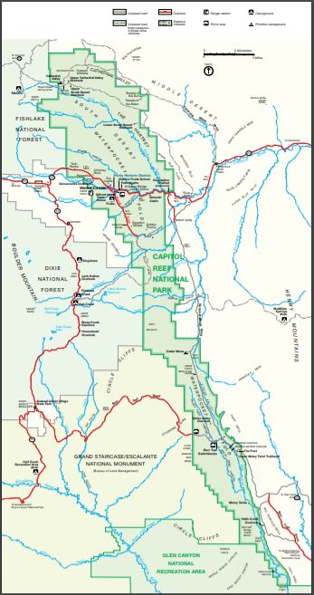
The Mighty 5 Utah National Parks: Capitol Reef
Capitol Reef National Park is a true hidden gem in the midst of a lot of them. The park is comprised of a massive wrinkle in the earth’s crust some 100 miles long. The park follows this “Waterpocket Fold” for about 70 miles north and south and is only about 10 miles wide at its widest point.
The northern 1/3 of the park is the most traveled with the exposed fold creating a surreal twisted landscape of cliffs (thus the name “Reef”), white sandstone domes (thus the name “Capitol”), and weathered out bowls called water pockets (thus the name…well…you get it.) The northern end of the fold terminated in a dramatic nearly vertical group of monoliths known as Cathedral Valley. Many of the red sandstone spired are topped by harder white rock giving a very dramatic appearance.
Though Capitol Reef is not as heavily visited as some of the other parks, it is possibly the most spectacular given that there is no consistency at all to the landscape. Each different area has a new rugged vista to explore.
Along the main road thru the park is the historic town of Fruita where you can pick apples to eat for free. You can also get an incredible handmade personal fruit pie and ice cream at the Gifford Homestead! Yummy!
Capitol Reef National Park Map
Capitol Reef National Park: Sites/ Hikes
Capitol Reef has an abundance of hiking including well worn to truly wonderous views (like the Hickman Bridge trail) as well as lesser used slot canyons and adventure hikes (like the Halls Creek Narrows). There is something for everyone here.
See a complete list of hiking trails here. Cassidy Arch is a favorite as you can get a picture of yourself standing ON TOP of the arch as the trail ends above, not below it. Some of the other hikes require travel by 4WD vehicles or at least high clearance vehicles.
Capitol Reef National Park: Surrounding Area
The area around Capitol Reef is beautiful and an awesome place to explore. There are ample opportunities for outdoor recreation. The town of Torrey to the West of the park is the only town in the area of any size and it is very small but nice. There are accommodations there as well as some restaurants.
Capitol Reef National Park: Camping
There are 3 campgrounds within Capitol Reef National Park. The Fruita Campground in the town of Fruita is quite pretty. It is very green and has a good deal of trees. The camping area is surrounded by the historic orchards as well.
There are no hookups but there is a dump station and water fill station. There are 64 RV sites with fire pits and 7 walk-in tent sites with grills. There is a reservation system during the busy season (March thru October) for most of the sites but a few do stay first come first served. The fee is $20.
There are also 2 primitive areas in the park for Capitol Reef camping. They are both free and are located at Cathedral Valley and Cedar Mesa. Both campgrounds only have a few sites with no services outside pit toilets. These sites are first come, first served year around. The sites do have picnic tables and fire rings.
Outside the park, there are quite a few options. There are Federal and Campgrounds all around, quite a few private RV parks (google RV parks, Good Sams, etc.) with varying costs and boat loads of boondocking options. Finding a campsite should not ever be an issue if boondocking is an option. If not, calling ahead is always a good idea. During busy times the campgrounds will fill up.
Capitol Reef National Park: Weather
Capitol Reef is in an arid desert climate. As such it only averages just over 7 inches of rain a year. So while the chances of rain overall are not high, the area is prone to flash flooding during June thru October. Always check the local forecast and talk to the Rangers at the visitors center before hiking any areas that might flood. Summer months can be very hot, averaging around 90 degrees. The cooler spring and fall months can be fantastic times to visit the park.
Winter is a lovely time to visit this park keeping the cold temperatures in mind. Average days are between 20 and 40 degrees and wind is sometimes difficult. However there is not a lot of snow so hiking can be done. Most local businesses close for the winter but there is camping available.
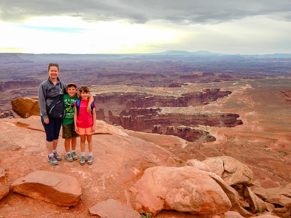
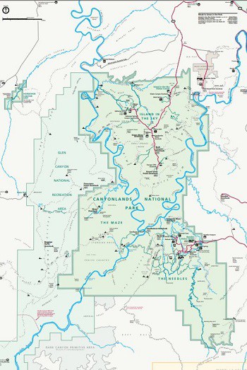
The Mighty 5 National Parks: Canyonlands
Canyonlands National Park was a huge surprise for us. We had never heard much about it. It is very near to Arches so we made sure to go have a look. What a surprise! This is a really spectacular place, and from a scenery point of view, it is on a par with any of the Mighty 5 Utah National Parks.
There are actually 3 different parts of Canyonlands NP, Island in The Sky, Needles, and Mazes. These areas are separated by the Colorado and Green Rivers which are also responsible for the formation of the canyons themselves. Since there are very few places to cross these rivers, traveling from one to the others requires a good bit of road time.
Island In The Sky is the most visited and most accessible part of the park. There is a Visitors Center and sparse amenities scattered throughout, but as with the rest of this park, the design is to be minimally intrusive, so don’t expect to see a big lodge or restaurant anywhere in the park.
This portion of Canyonlands sits high on a mesa overlooking a good deal of the park. 1000 feet below the rivers can be seen meandering their way through and cutting away these awesome vistas. There is a paved road which follows the rim of the mesa and offers incredible viewing opportunities of the canyons below. Each pullout gives a different viewpoint and together they offer a 360-degree view.
Some of the most awe-inspiring spots are Grand View Point, which is at the end of the road. The views and hike at Grand View Point are indescribable, but the canyons below look like a huge dinosaur left a really big footprint. A side road will take you to Whale Rock and Upheaval Dome, a massive bubble of salt that was pushed up out of the ground by as yet unknown forces.
The resulting landscape looks like the surface of a distant planet. In the center area of the park at the intersection of the roads is Aztec Butte, Mesa Arch, and Green River Overlook. Aztec Butte includes ruins of some old Indian storage spaces built into the overhang at the edge of the butte. The kiddos loved wandering around this site and wondering how these ancient people lived.
The Needles area of the park is far to the south and accessible south of Moab. It is a much more rugged area and best explored by 4WD to reach some of the less traveled areas. This section of the park is known for its colorful sandstone spires, the result of millions of years of erosion and weathering. This is a hikers and backpackers heaven and there are ample opportunities for even the most adventurous of hikers. There is a Visitors Center at the entrance where you can stop to get maps and discuss explorations prior to hitting the trails.
The Maze district of Canyonlands is the most remote. It can only be accessed by high clearance 4WD vehicles and does not offer any amenities. This part of the park is for the more adventurous and is so remote that trips of less than 3 days into this area are rare. Visitors must be self-sufficient and equipped for self-rescue. We did not visit the Maze.
Canyonlands National Park Map
Canyonlands National Park: Sites/ Hikes
The different areas of Canyonlands National Park offer something for everyone. The views here are spectacular as are the hiking trails. Each of the main areas offers hikes of varying difficulty but to at least take some of the shorter, easier hikes will deliver rewards to the senses and vistas that cannot be experienced anywhere else.
Our favorites were the Aztek Buttes trail, the Grand View Overlook trail, and the 2 observation points at Upheaval Dome. We also wandered out to the upper Murphy Point view which was just awesome- what a HUGE landscape! There are also any number of back country trail options which can be quite difficult and remote- depending on your comfort level there is something for everyone.
Canyonlands National Park: Surrounding Area
Moab is the only real option for exploring the different areas of Canyonlands. It somewhat centered between the Islands and Needles districts and has all of the necessary amenities. There are ample opportunities for adventure tours and activities and plenty of camping as well. The town of Monticello is south of the Needles entrance but would not be good for the Islands portion.
Canyonlands National Park: Camping
There are only 2 options in the park for Canyonlands National Park Camping. Willow Flat campground is in the Islands In The Sky district. There are only 12 sites here and no amenities outside vault toilets. Water is available at the Visitors Center. It is centrally located near the Green River Overlook. Sites are $15 per night and are first come…
Squaw Flat is on the Needles District. There are 26 sites and a few group sites as well. These are also first come except for a few that are reservable in spring and fall. There are toilets, picnic tables, and fire rings in the campground.
Canyonlands National Park: Weather
Canyonlands experiences the full gamut of weather. The spring and fall are the best times to visit as the weather is milder. Summers are hot with many days over 100 degrees.
But the days are long and evenings are pleasant. Winters are cold but there is not a lot of snow so hiking many parts of the park is quite accessible. The Visitors Center is closed, but days are generally warm enough to hike and there is virtually nobody there.
So there you have it- there is no reason on earth not to visit Utah and it’s many parks as soon as possible. In fact, if you don’t you are really missing out on some of the most spectacular scenery anywhere on earth.
Camping in southern Utah is plentiful and there are an abundance of parks and places of interest even outside the Mighty 5 Utah National Parks. There are so many must see places in Utah so best to get started. For your next vacation start planning your own Ultimate Utah National Parks Road Trip. You won’t be sorry!
Have you traveled to Utah? Tell us about your own experiences in the Mighty 5 Utah National Parks.
If you’re interested in following us along on our travels, you can follow us on Instagram, or on facebook here or come join our facebook group.
PIN FOR LATER
[apsp-pin-image image_url=’https://www.pinterest.com/pin/605804587356167773/’]
Grainne Foley
Grainne Foley grew up in Ireland and spent summers caravanning around Europe with her family. Now, as a wife and mother of 2, she spent 5 years traveling the USA as a full time RVing family. She is passionate about travel, and helping others who are considering the RV lifestyle. She has created dozens of helpful RVing checklists which are available throughout the website, and has curated hundreds of simple, flavorful meals for families on the go.

This is fantastic – thank you! I just arrived in Moab and are hitting up all five parks in only four days so it’s great to find out the highlights.
Brilliant, you will love it there. 5 parks in 4 days – Wow! Good luck.
We will be in Moab in a few weeks. After reading your blog, sadly I realize it won’t be for nearly long enough. Your comments and recommendations will help us find those hidden gems though. Thank you for the time and effort in posting all this information and your experiences. Love your adventurous life.
Hi K,
Moab is awesome. Visit less places more. You can hit both Arches and Canyonlands easily from Moab though so…plenty to do. Have a great time!!
My husband is a college football coach whose time off is limited.This year it starts April 18. We try to do a bucket list things with just the two of us every year since our daughter got older. Cruising has been our thing lately in the Baltic, British Isles, Caribbean and Alaska. But of course that is out until at least April 30. And traveling out of the country is not something we consider advisable at this point. So, I went on a list of top 50 places to go in 2021 in the US and found glamping at the Grand Canyon with a company called Under Canvas. Glamping has been a bucket list thing for me for about a year and Utah looks amazing. We are avid hikers but he is more fit than I am. Under Canvas also has sites at Moab and Zion and a new one opening at Lake Powell. We hit the ground running and try to see and do as much as we ca. So, I am considering a glamping road trip. Writing is my vocation and I am on deadline so I don’t have a lot of time to plan. Your website is saving me a lot of time! Yeah! Thanks and Kudos! If we just have a week, what is your recommendation?
Hi Stephanie,
If you have only a week, I would choose Moab. We saw the Under Canvas location when we boondocked there and it looked absolutely wonderful. The reason I would do Moab is that you have 2 National Parks at the ready- Arches and Canyonlands. In fact- the Under Canvas site is nicely placed right between the 2, and just a couple of miles outside the town of Moab (which is a great town!) Both NP’s offer a tremendous variety of hiking opportunities, from shorter hikes out of the parking lot to extreme backcountry experiences, so you will not go wrong. These 2 parks are also completely different experiences and offer a lot of variety. You COULD do all of the Utah parks in a week, but we always recommend NOT trying to fit too much in. We always say “See less, more.” Trying to fit in too much leaves you feeling rushed and dissatisfied. You could easily spend a week at any of the individual parks but at least Moab gives you 2 and enough time to explore and get to know them. Check your dates carefully- there are a lot of events in Moab in April- it is a perfect month weather-wise so a lot of people visit and there are some big gatherings around that time. Hope you have an AWESOME trip!
Thank you so much, this is such rich and helpful information. I just planned half my trip around your article!
Awesome Olivia, so glad we could help